Buying a Home in Florida? Don’t Overlook Flood Risk
Buying a Florida home? Learn how to assess flood risk, read FEMA maps, and protect your investment from hidden hazards and rising water.

Buying a Florida home can be exciting — but flood risk is often overlooked. Hurricanes, heavy rains, and rising seas make it crucial to know a property’s floodplain status before you buy.
This guide walks you through five key steps to assess flood risk, engage local experts, and build long-term resilience.
Why Floodplains Matter in Florida
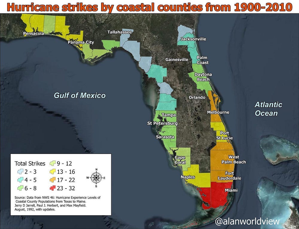
Florida’s low elevation and extensive coastline make it one of the most flood-prone states in the U.S. The National Oceanic and Atmospheric Administration (NOAA) projects a 10–12 inch sea level rise along Florida’s coasts by 2050 (NOAA Sea Level Rise Report). Colorado State University’s April 2025 forecast estimates a 22% chance of a major hurricane (Category 3–5) hitting Florida’s east coast and a 28% chance for the Gulf Coast (CSU Hurricane Forecast).
A floodplain is like a bathtub — too much water spills over, often into areas that seem safe. FEMA maps are helpful, but they don’t guarantee safety. They reflect the best data available at the time they were created, but they don’t account for everything — especially changes from new development, climate change, or more intense storms. In a growing state like Florida, flood risks are constantly shifting. That’s why it’s important to stay informed and check with local officials before making property decisions.
1. Use FEMA Flood Maps
FEMA’s Flood Insurance Rate Maps (FIRMs) show a property’s flood risk:
Access Maps: Visit FEMA’s Flood Map Service Center and enter the property’s address.
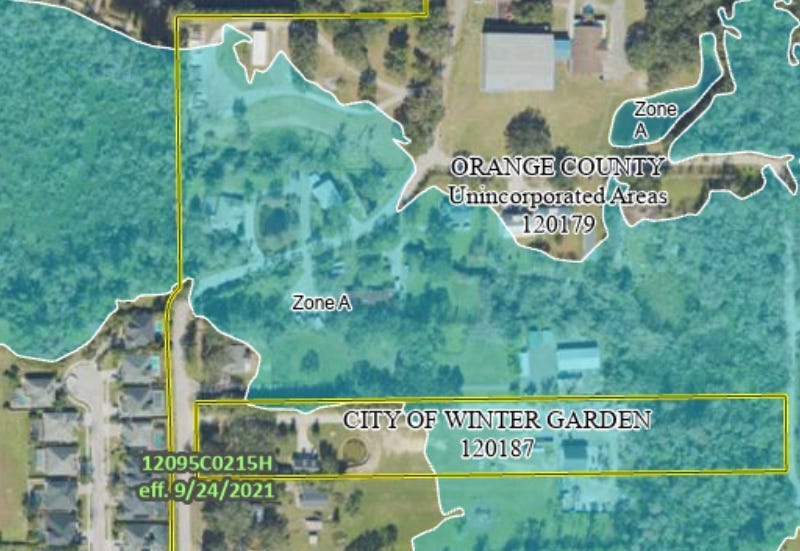
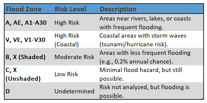
Look up your flood zone: If your property is in a high-risk area (Zones A, AE, AH, AO, V, or VE), you face what is known as a “1% annual chance flood” — formerly called the “100-year flood.”
Over a 30-year mortgage, that’s roughly a 26% chance of flooding — or 1 in 4 odds. (FEMA Flood Risk).
Beware of Unmapped or Incomplete Zones
Not all areas have been studied for flood risk. Properties in Zone D (undetermined risk) or Zone X may appear safe, but this could reflect a lack of data — not a lack of danger. Many rural, rapidly developing, or inland areas in Florida haven’t been modeled or are based on outdated studies.
FEMA maps also don’t capture localized drainage issues, sea level rise, or stormwater runoff from nearby development. Always ask your local floodplain administrator if a Base Flood Elevation (BFE) exists, if new studies are underway, or if past flooding has occurred — even if it’s not shown on the map.
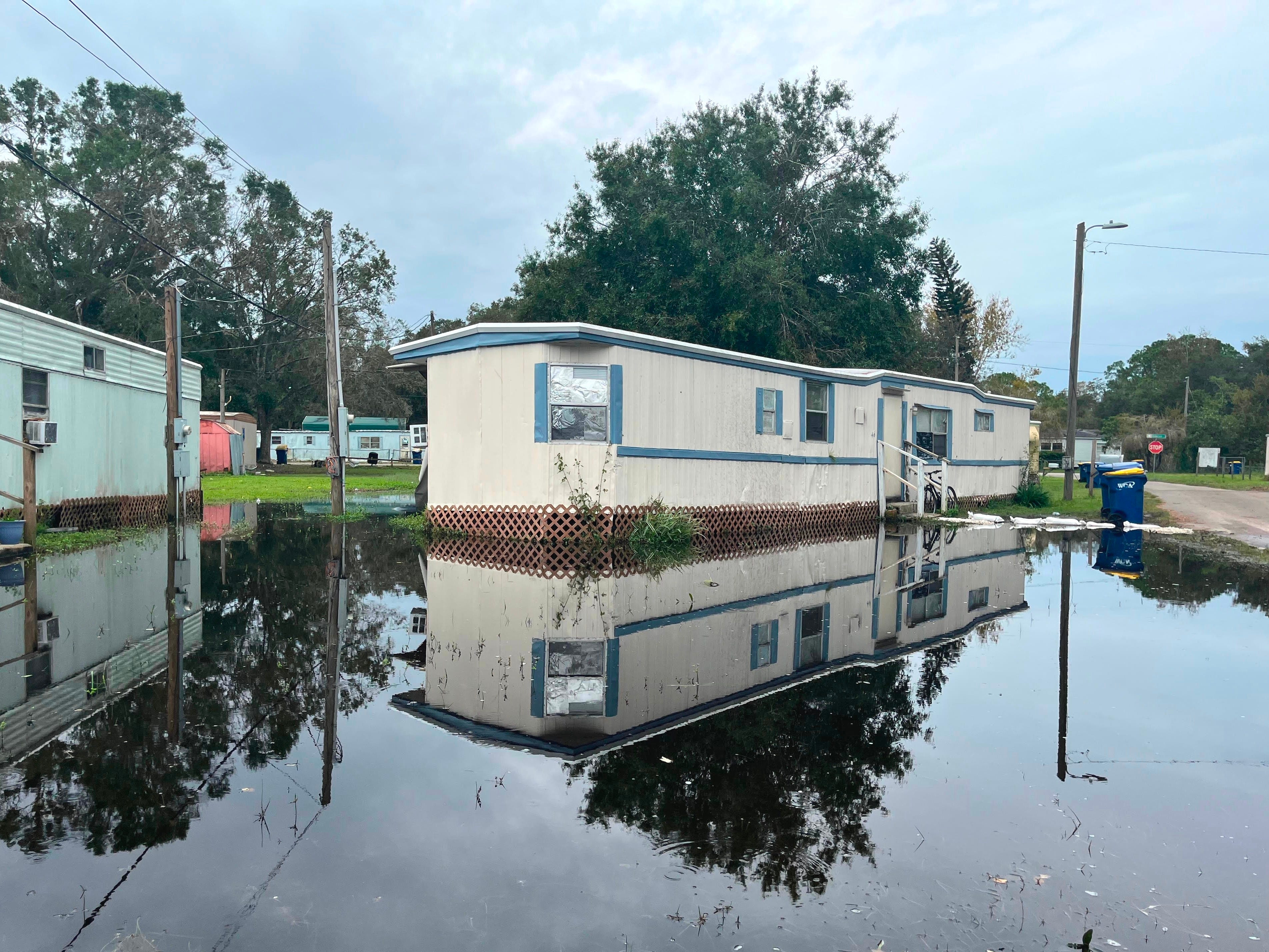
A friend of mine purchased her dream home — a cabin-style house in rural Florida. After just one strong storm, the entire first floor flooded. The FEMA map for her area was marked “Not Printed,” meaning no flood study had ever been done.
I wasn’t yet a Certified Floodplain Manager at the time, but that event stuck with me. Later, as I studied floodplain mapping more deeply, I realized just how critical that missing data was. That missing data — and the consequences of relying on outdated maps — are explored further in my companion article, Why Do We Still Build in the Floodplain? It reinforced a hard truth: maps are just the starting point. (More on this in an upcoming story.)
Don’t assume safety just because the map is blank. Ask questions. Visit the site. Seek local knowledge and expert input before making a major investment.
2. Investigate Property Details
Don’t rely on maps alone — some of the most important flood clues are found on-site or through local knowledge. Research the property’s flood history and characteristics:
Visit the property, ideally during or after rain. Watch for pooling water, poor drainage, or low-lying features.
Talk to Neighbors about past flooding, water marks, or drainage problems. Local insights often reveal risks not on maps.
Request Seller Disclosures. Florida law requires sellers to report known flood issues (Florida Realtors Disclosure). Demand records of past floods or repairs.
Obtain an Elevation Certificate. It shows how the building’s lowest floor compares to the Base Flood Elevation (BFE). Homes built above the BFE face less risk and lower insurance premiums
3. Consult with the Local Floodplain Administrator
Nearly all Florida communities participating in the NFIP have a designated floodplain administrator:
Role: A Floodplain Administrator is the local official responsible for enforcing floodplain regulations, reviewing development proposals in flood-prone areas, ensuring compliance with FEMA and NFIP standards, maintaining floodplain records, and providing guidance to the public about flood risks and mitigation
How to Find Them: Contact your city or county building, planning, or engineering department. Many local governments offer online flood information resources or hotlines.
What to Ask: Inquire about flood zone changes, local flood history, or construction requirements.
4. Understand Flood Insurance
Floods aren’t covered by standard homeowners’ insurance. In high-risk zones, lenders require NFIP coverage:
Standard homeowners’ insurance does not cover flood damage. If your property is in a high-risk flood zone and you have a federally backed mortgage, your lender will require flood insurance through the National Flood Insurance Program (NFIP).
Premium Costs: Flood insurance premiums in Florida are determined by several factors, including your property’s location, elevation, construction details, and other risk characteristics. Use FEMA’s Cost Estimator.
Risk Rating 2.0: Since 2021, FEMA’s Risk Rating 2.0 system sets premiums based on the specific risk profile of each property, rather than just flood zones and elevation. This means rates are more individualized. You can obtain quotes through the NFIP or from private flood insurance providers.
Low-Risk Zones: Even if your property is in a moderate- or low-risk area (such as Zone X), flood insurance is still recommended. Flooding can happen anywhere, and over 40% of flood insurance claims come from outside high-risk zones.
5. Plan for a Changing Climate
Flood risks in Florida are increasing due to climate change and rapid population growth. As more land is developed with roads and buildings, natural drainage decreases, leading to greater runoff and higher chances of flooding.
Sea Level Rise:
Florida’s long coastline and low elevation make it especially vulnerable to sea level rise. Even small increases in sea level can cause more frequent and severe coastal flooding, higher storm surges, and saltwater intrusion into groundwater. Tools like NOAA’s Sea Level Rise Viewer can help visualize future flood risks, but remember that flood maps are snapshots — new development or major storms can quickly change local risk.Population Growth and Runoff:
Florida’s population continues to grow, increasing urban development. More impervious surfaces, such as roads and buildings, reduce the land’s ability to absorb rainwater, worsening flooding. This means that even areas currently considered low-risk can become more vulnerable as cities expandEvolving Flood Maps:
As climate and development patterns change, floodplain maps can become outdated. Stay informed about local updates and consider future risks, not just current maps, when making property or insurance decisions.
Conclusion
Your Florida dream home deserves protection from flood risks. Use FEMA maps, visit the property, talk to neighbors, consult your local floodplain administrator, and secure insurance. With a 1% annual chance flood posing a 26% risk over a 30-year mortgage, and maps outdated by population growth and runoff, due diligence is critical. Resources like FDEM’s guides and local experts ensure your home stays safe in a flood-prone state.
Disclaimer: The views expressed in this article are solely my own and do not reflect those of any public agency, employer, or affiliated organization. This blog aims to educate and empower readers through objective geographic and planning insights, fostering informed discussion on global and regional issues.